May 11th, 2023
Key Findings
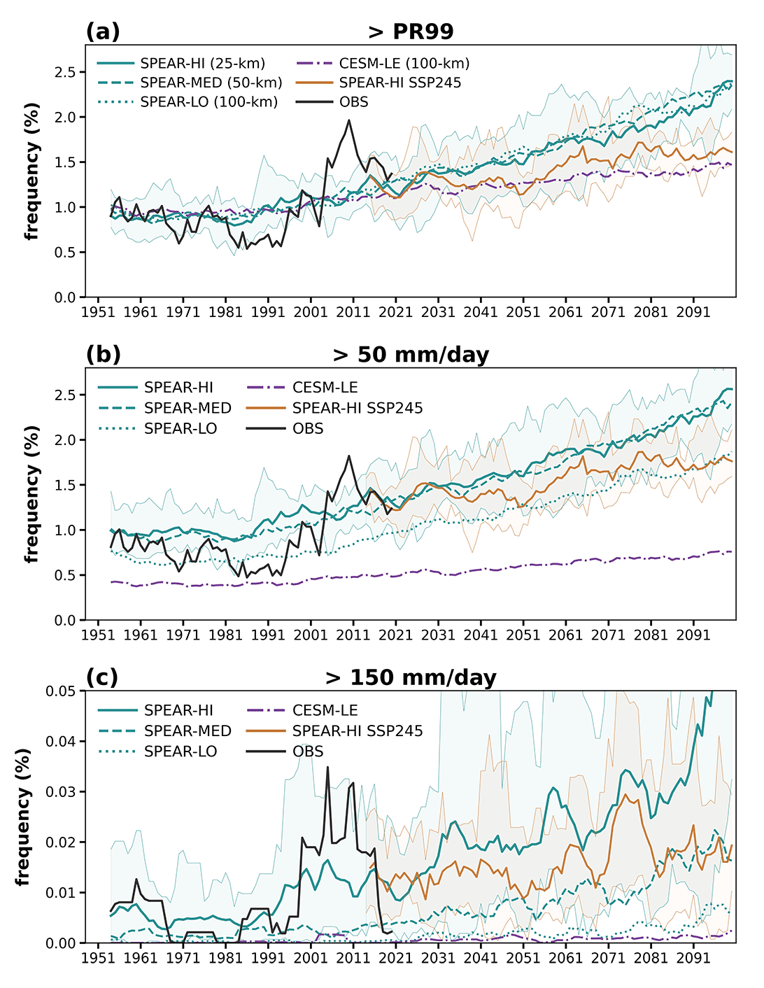
- A climate model with 25 km horizontal resolution simulates much more realistic extreme precipitation over the Northeastern U.S. than comparable models with 50 or 100 km resolution, including frequency, amplitude, and temporal variability.
- By the mid-21st century, the model projects unprecedented rainfall events over the region, driven by increasing anthropogenic forcing and distinguishable from natural variability under the IPCC’s SSP5-8.5 scenario.
- Future projections show that extreme precipitation, defined as the top 1% of daily precipitation based upon historical climatology, would double its frequency by the end of the 21st century under the SSP5-8.5 scenario.
- The increasing rate, however, is not uniform for all intensities among the extreme precipitation range: the very extreme events (>150 mm/day) would be six times more likely by 2100 than in the early 21st century.
Bor-Ting Jong, Thomas L. Delworth, William F. Cooke, Kai-Chih Tseng, Hiroyuki Murakami. npj Climate and Atmospheric Science. DOI: 10.1038/s41612-023-00347-w
Extreme precipitation is among the most destructive natural disasters. Simulating changes in regional extreme precipitation remains challenging, partially limited by the horizontal resolution in climate models. For this study, the authors used an ensemble of high-resolution (25-km) global climate model simulations to study extreme precipitation over the Northeastern United States, where extremes have increased rapidly since the mid-1990s.
Future projections with GFDL’s new high-resolution climate model, Seamless system for Prediction and EArth system Research (SPEAR), show that by the mid-21st century, unprecedented rainfall events could occur over the region, driven by increasing anthropogenic radiative forcing and distinguishable from natural variability. Very extreme events (>150 mm/day) may be six times more likely by 2100 than in the early 21st century, under the Shared Socioeconomic Pathway 5-8.5 (SSP5-8.5), high-end projection of future greenhouse gas emission.
Detecting and projecting changes in extreme precipitation on regional scales remain highly challenging and uncertain. Global climate models, typically with atmospheric resolution ranging from 100 to 200 km, are not sufficient to resolve the most extreme precipitation events and generally underestimate the rate of occurrence of the most extreme rates of precipitation. Enhancing a model’s horizontal resolution has been shown to improve the simulated frequency of extreme precipitation markedly, as higher precipitation rates are permitted by the higher-resolution model. Also, models with finer resolutions better represent several physical processes related to extreme events such as tropical cyclones, extratropical transition, mesoscale processes, atmospheric rivers, and quasi-persistent weather regimes, compared to models with coarser resolutions.
The authors focused on extreme precipitation from September to November, as the fall season has the most robust trend. A variety of horizontal resolutions (from 100 to 25 km) in the atmosphere and land components of the model were tested to demonstrate that a finer resolution model facilitates a more realistic simulation of extreme precipitation frequency than a coarser resolution model. The 25-km SPEAR shows remarkable performance in simulating the observed extreme precipitation frequency and variability over recent decades compared to comparable models with 50 or 100 km resolution.
As the Northeastern United States has faced the most rapidly increasing frequency of extreme precipitation within the United States in the past few decades, there has been rising concern about whether existing infrastructure is at risk of possible changes in a future warmer climate.
This study enhances our understanding of how the frequency and amplitude of extreme precipitation events will change in the future.
OAR’s goals: “Detect Changes in the Ocean and Atmosphere – Produce, analyze, and interpret observation records to understand the Earth system and inform the public.“