February 10th, 2025
Key Findings
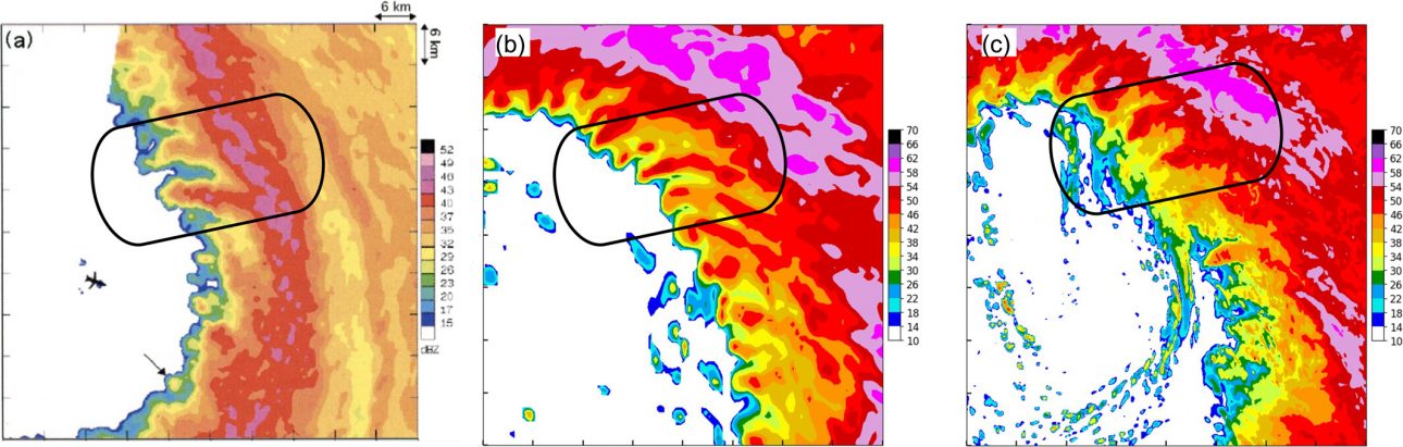
- A O(100 m) grid spacing simulation was conducted that captures the finger-like features along the inner edge of the hurricane eyewall.
- The authors propose that these features are generated due to the Kelvin–Helmholtz instability associated with the tangential wind in the hurricane inner-core region.
- This proposed mechanism explains the emergence time, frequency, radial location and vertical extent of the finger features.
Kun Gao, Joseph Mouallem, Lucas Harris. Geophysical Research Letters. DOI: 10.1029/2024GL110810
The inner core region of hurricanes harbors complex dynamical features, including small-scale clouds characterized by finger-like appearances pointing toward the hurricane eye. These features have been frequently observed in intense hurricanes. However, many basic aspects of these features remain unknown, particularly regarding what controls their occurrence, location, and spatial distribution. The authors conducted a numerical simulation with a very fine (about 100 m) horizontal grid spacing to investigate the nature of these features. Their results reveal a mechanism which explains several key characteristics of these features.
The GFDL System for High-resolution prediction on Earth-to-Local Domains (SHiELD), was used to conduct a multi-level nested simulation which has an innermost 125m resolution grid, focused on the hurricane inner core region. The simulation depicts the evolution of an idealized hurricane vortex over a 96-hour period. This is likely the first published effort to use ~100 m grid spacing to simulate the entire vortex intensification period.
The simulation successfully captured the finger-like clouds located along the inner-edge of the hurricane eyewall, resembling the observed features. The authors documented the key characteristics of the eddy features responsible for the formation of these finger clouds and proposed that these features are formed primarily due to the shear instability associated with the tangential wind distribution in the hurricane inner region.Their findings explain several key characteristics of these features, including their emergence time, frequency, relative radial location, and radial-vertical geometry.
Beyond scientific discovery, this work demonstrates the feasibility and utility of multi-level nested simulations with ~100 m grid spacing, marking a significant step toward incorporating ultra-high-resolution modeling in operational hurricane prediction systems. Such advances could improve the accuracy of intensity forecasts, which are critical for disaster preparedness and mitigation. Furthermore, this study lays the groundwork for next-generation NOAA operational hurricane models, offering a pathway to better capture fine-scale structures and their dynamics that influence storm behavior.